8:35 AM
Wednesday
2 Jul 2025
Sunrise
5:58am
Sunset
9:04pm
Temperature
72.2°F
Low Today
61.1°F
6:03a
High Today
72.2°F
8:33a
Avg Low
64 °F
Avg High
82 °F
Rec Low
47 °F
1943
Rec High
97 °F
1954
Humidity
97%
Dewpoint
71.3°F
Air feels
very humid
Rain
0.01"
Max rate 0.01"/hr at 6:00am
Month to date
0.34 in
Year to date
28.63 in
Wind
Calm
Barometer
29.96 inHg
Rising Slowly
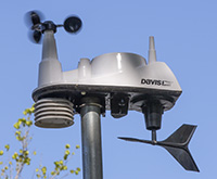
Data in the blue boxes above are updated every five minutes from a wireless Davis Vantage Vue installed August 29, 2017.
Inside: 75.6°F / 44%
Moon: First Quarter
Moon: First Quarter
NWS Climate Data Video
NWS Hazards Map
NWS Winter Forecasts
NWS Precipitation Map
NWS Precip Map Day 2
NWS Precip Map Day 3
Weather Fronts
WPC 6-hour PQPF
NWS Temps Change Map
6-10 Day Temp Outlook
Monthly Temp Outlook
6-10 Day Precip Outlook
Monthly Precip Outlook
NWS Weather School
Digital Weather Display
NWS Hazards Map
NWS Winter Forecasts
NWS Precipitation Map
NWS Precip Map Day 2
NWS Precip Map Day 3
Weather Fronts
WPC 6-hour PQPF
NWS Temps Change Map
6-10 Day Temp Outlook
Monthly Temp Outlook
6-10 Day Precip Outlook
Monthly Precip Outlook
NWS Weather School
Digital Weather Display
Glossary of Meteorology
COD Weather Models
NWS Weather Modeling
AI Weather Forecasting
HRRR Weather Model
HRRR Explained
NAM Explained
ECMWF-ENS Explained
National Blend of Models
Tropical Tidbits
Forecast Tools
Pivotal Weather
GenCast AI Modeling
Atmospheric Rivers
Climate.gov
GOES-East Satellite
GOES-West Satellite
COD Weather Models
NWS Weather Modeling
AI Weather Forecasting
HRRR Weather Model
HRRR Explained
NAM Explained
ECMWF-ENS Explained
National Blend of Models
Tropical Tidbits
Forecast Tools
Pivotal Weather
GenCast AI Modeling
Atmospheric Rivers
Climate.gov
GOES-East Satellite
GOES-West Satellite
Click or tap for a detailed NWS 7-day Forecast
Today: Sunny, with a high near 85. Northwest wind 2 to 9 mph.
Tonight: Mostly clear, with a low around 65. West wind 2 to 8 mph.
Thursday: A slight chance of showers and thunderstorms after 2pm. Sunny, with a high near 84. Northwest wind 5 to 9 mph. Chance of precipitation is 20%.
Thursday Night: A slight chance of showers and thunderstorms before 8pm. Mostly clear, with a low around 63. Northeast wind 2 to 7 mph. Chance of precipitation is 20%.
Independence Day: Sunny, with a high near 86. South wind 2 to 6 mph.
Friday Night: Partly cloudy, with a low around 67.
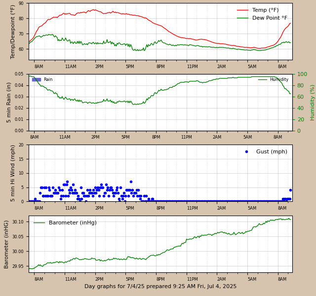
Graphs above are updated every 5 minutes by a Python program using Matplotlib routines running on a Raspberry Pi 4 computer.
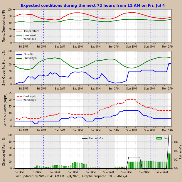
The forecast graphs above are prepared at 58 minutes after each hour. Hours between sunset and sunrise are shaded. Graphs are based on data in a json file downloaded from https://api.weather.gov/gridpoints/CLE/82,55. NEXT 7 DAYS